SLHS: Street Names Changed


Disclaimer
Whilst some care has been taken to check externally linked websites no responsibility is offered nor implied for the suitability, legality or reliability of content therein.
Statements are made here to the best of our knowledge. However no statement here should be regarded as irrefutable fact. Please contact us if you consider otherwise.
History
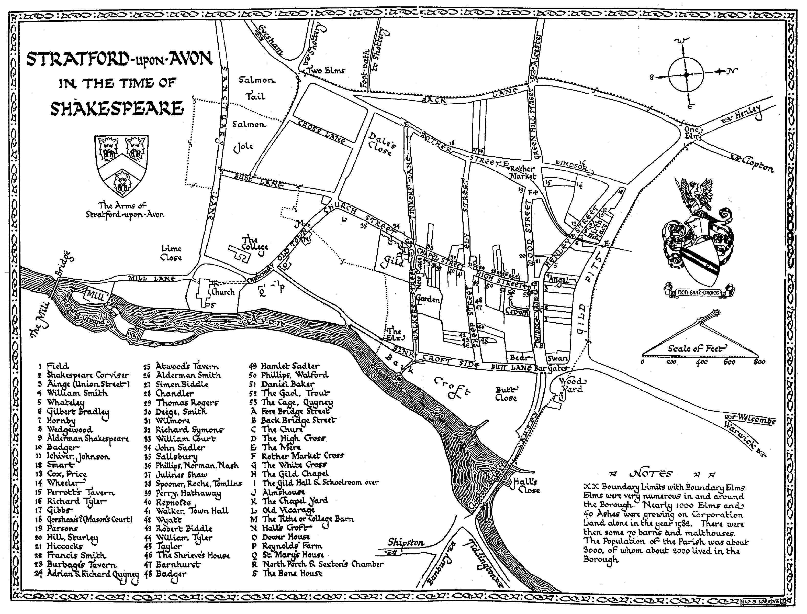
It’s obvious that any town will change over a period of 400 years. Let’s have a look at how the names have changed since the year 1600 (starting at the top of this map)..
Street Name Changes
-
Arden Street was Pound Lane until 1879
-
Bancroft Gardens was an open field called Bank Croft and Butt Close
-
Bishopton Lane was Sealt Stret (Salt Street)
-
Bridgefoot was called The Causey
-
Bridge Street had slums down the middle, Middle Row, which were pulled down (link to go here)
-
Bull Street was Bull Lane
-
Chapel Lane was Walkers Street or Dead Lane (both continued all the way to the river)
-
Cox’s Yard was much further from the river opposite Swan Gates
-
Ely Street was Swine Street
-
Evesham Crossing had a pub “The Two Elms”
-
Greenhill Street was More Town End
-
Grove Road was Back Lane
-
Guild Street was Gild Pits (this originally was an open sewer with much effluent from the brewery)
-
Hathaway Lane was Shinners Lane
-
Loxley Road was Hares Lane
-
Lucy’s Mill Bridge was wooden at this time.
-
Maybird Centre N (where Tesco is) was called Rathmines Terrace (no apostrophe on doc we have)
-
Mayfield Avenue was Burman’s Lane
-
Mere Street was Mere Pool Lane
-
Narrow Lane (Old Town) was Love Lane.
-
New Broad Street didn’t exist (that’s why it’s new)
-
Sanctus Road was Sanctuary Lane was Sancty Lane.
-
Scholars Lane was Tinkers Lane
-
Shipston Road was London Turnpike
-
Shottery Road was Berrin’ Row (apostrophe because it’s short for “buried in”)
-
Southern Lane was Southam’s Lane
-
Waterside was Bank Croft Side and Butt Lane
-
West Street was Cross Lane
-
Pub Name Changes
-
The Arden Hotel was “The Elm”
-
The Encore was The Anchor was The Bear
Further Information..
-
Stratford Society
-
For a description of Stratfords social state, including some riots and brawls, in the period 1558-83 see: Prominent People: Bob Bearman
-
Index to all material: Site Map
-
-
British History Online
-
Full potted history: Borough of Stratford-upon-Avon
Town centre only

This map is available at Stratford Society

Page Data Updates
Old links may not work.
Please goto Home page and refresh.
Dec2023
Town Centre Grid Layout
Two years before he died John de Coutances decided to set up a town near the “Strait Ford”. However he wisely thought to leave the original Roman garrison, on the South side of the river, and set up his new town on the North side based upon a grid pattern.
Consecutive House Numbering
See shortcut above.
To return to Master page click on ‘Streets’ above.
-
● Full
-
● Partial
-
● None
-
Theatres ●
Last update: 04/12/2024
Created: 23/09/2024