
SLHS River Avon Navigation History


Disclaimer
Whilst some care has been taken to check externally linked websites no responsibility is offered nor implied for the suitability, legality or reliability of content therein.
Statements are made here to the best of our knowledge. However no statement here should be regarded as irrefutable fact. Please contact us if you consider otherwise.
Source
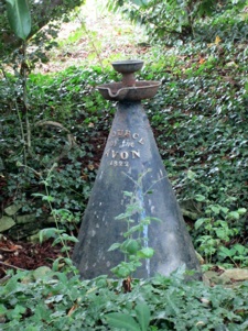
The 140 mile River Avon has had its source marked for 200 years by a cast iron ‘fountain’ opposite All Saints Church, behind Naseby Village Store, Northamptonshire. There’s a little circle of rocks marking the spot but it has been dry for at least 50 years so the next wet patch is actually Naseby Reservoir 1½ miles away.
Further Information..
-
UANT Quick History: History Of making The Avon Navigable.txt
-
UANT Extension pdf coming soon..
-
Inland Waterways Association: Extent Of Navigation Of River Avon (with dates)
Naseby to Tewkesbury
● These items have aspects that uniquely contribute to national or world history.
River Avon Seen As Key To Prosperity For All
Going way back in history all rivers, that are deep enough, will have had things floated on them. Ferries were probably the first commercial craft. Of course all rivers respond to the downpours in their catchment area so making summer and winter navigation vastly different in most cases. The Avon was no exception. However it seems to be the first river in the country to have someone control its flow in order to make navigation possible.
Sandys First To Make Avon Navigable
In 1635 William Sandys was granted letters patent by Charles I. By construction of weirs and locks in just 3 years he made navigation over the 47 miles between Stratford and Tewksbury routine in all but the worst of outright flooding. This was an amazing achievement for the time.
Yarranton Plans Huge Expansion In Trade
The Worcestershire Engineer and agriculturist, Andrew Yarranton (1616-1684), visited Holland and decided to bring those ideas here.
Stratford: New Haarlem
He planned to make Stratford the centre of the corn trade with a new centre near Milcote at the junction of the River Avon and River Stour which he was going to call New Harlem.
Lower Avon Restoration
World War 2 had decimated all countries in Europe. By the 1950s initial reparations had been made. Britain was spent but non-military industries were getting on their feet again. Increasingly road transport was competing full on with rail. In 1959 the M1 was opened and for 6 years it had no speed limit ! Except for Manchester/Liverpool, Bristol, Southampton and, to a quickly declining extent, London were the only places viable for mass water transport.
However a small, but increasing number, of workers had leisure time on their hands and the use of outdoor waterways was seen as a healthy pursuit. in 1946 the Inland Waterways Association had been established and just four years later they turned their gaze upon our dear river for their very first restoration. Good for them.
Giving Douglas Barwell the task in 1950 the charity The Lower Avon Navigation Trust was set up. It was a huge task to bring 17th century installations up to modern standards. By mobilising vast numbers of volunteers and raising money by charitable donation no strain was put on the public purse. For additional labour he turned to The Royal Engineers to offer them training opportunities in all manner of mechanical skills. Twelve years later it was finally reopened in 1962. Such was the example given to the whole of the rest of the country that Douglas received an OBE.
● First Restored River By IWA
Remainder Of Lower Avon Restoration
This now left the the river above Evesham looking like a sore thumb but Douglas had had enough. From 1963 known, and a generous anonymous, benefactor began offering contributions so in 1965 the charity The Upper Avon Navigation Trust was set up. Having just completed the very first canal restoration David Hutchings was put in charge.
However the upper Avon was a mess and badly prone to flooding and subsidence (which caught them out at Lucy’s Lock -hence the giant girders above and below ground). Four years planning was needed and funding was very tricky. It was the biggest project of its type to date. In 1971 David completed the first section, from Evesham to Bideford. Then in 1974 the remainder to Stratford was completed. Like the canal this was again opened by the Queen Mother and this time David was upgraded to MBE for his dedication.
New Extension Stratford To Leamington
In 1974, upon the above revered success, Severn Trent Water Authority considered extending navigation even further upstream in order to join up to the Grand Union Canal at Warwick thus avoiding vast numbers of locks.
What a great idea. Significant work was done in planning see separate page: Upper Avon Navigation

To return to Master page click on ‘River Avon’ above.
As the railways sprawled across the land their speed, convenience and flexibility decimated river traffic as soon as they were opened. The amazing thing was that when the GWR bought out the canal company for a song they actually ended up owning the river.
In 1877 local farmers then appealed to the Railway Commissioners for the river to be maintained up to standard. Not surprisingly they retorted by saying that GWR were not obliged to do so and so no more was done.
After 1870 nobody travelled further upstream than Evesham and by 1940 the river was unnavigable upstream of even Pershore. What a dereliction !
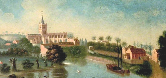
Lucy’s Mill ~1750 Edward Grubb
Trading as far as Clopton Bridge before the arrival of the canal and tramway ~1750 Edward Grubb
The Railways Decimate Waterway Trade
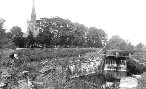
Lock by Holy Trinity Church was left and by 1880 was derelict. It is now known as Colin P Witter Lock
Upper Avon Navigation
The Steady Rise In Trade
This never came to pass however by 1800 there were 400 barges plying their trade. Maintenance and management of charges became such a big operation that in 1717 the Avon was divided into the now familiar Lower and Upper halves at Evesham. The former was leased by George Perrott in 1758. The Upper Avon Navigation was owned by relatives of Lord Windsor. In 1758 he died and sadly its condition gradually deteriorated.
In 1813 our hero William James bought it. However serious flooding made this part of the navigation fickle and he had to spend another £6000 making it navigable again. There was a period where on paper it appeared that he had more debts than assets. Competitors saw this and after some heated discussions he, just as Marc Brunel did once, had to go to jaol for being technically bankrupt.
In 1842, with plenty of coal to hand, The Stratford Canal Company took the Upper Avon over. They spent even more money leveling stretches of river and controlling the rest. Their goal was to supply Evesham and the surrounding farms who were increasingly using steam traction engines for farming.
Of course Lucy’s Mill in Stratford had been extended to have two working water-wheels for milling grain. Less than one mile further upstream Stratford was the prime location for trade requiring firstly one large, then two, canal basins for the transfer of cargos between canal, river and eventually tramway. However this latter was to portent the end of use of the river.
Stratford New Brunswick
At that time John Clopton owned open fields where we now call Bridgetown but Yarranton planned wharves, grain storage, linen production, new industries and even a New Brunswick beer to be called “Mum”.
(Ref The Borough Town Of Stratford-upon-Avon LFox p65)

-
● Full
-
● Partial
-
● None
-
Theatres ●
Last update: 31/10/2024
Created: 10/09/2023